Ocean models
The equations that emerge are by no means primitive and cannot be solved analytically. Therefore, numerical methods are used to solve simplified versions of the equations on a predefined grid. The calculations are extremely computational demanding and require access to high-performance computers. Other names for ocean models can be circulation models, current models or hydrodynamic models.
A model simulation needs an initial description of the physical variables. Based on the initial conditions, the model use the simplified version of the primitive equations to calculate forward in time, controlled by external driving forces. Such driving forces are mainly wind and heat exchange with the atmosphere along with precipitation and evaporation, freshwater runoff from land and ocean conditions along the open boundaries of the model area. Tides are often imposed along the open boundaries. The atmospheric forcing is usually retrieved from an atmosphere model (reanalysis, weather forecast, climate projection), freshwater runoff from observed data or a hydrological model, and the boundary conditions from an ocean model simulation covering a larger area.
The quality of the model results can vary, and the quality of driving forces and boundary conditions as well as the resolution of the grid are important factors which are crucial to produce good results. The external forcing data must be complete, i.e., include the most important driving forces such as wind, tides, river runoff and internal pressure forces, and have sufficient resolution in space and time that matches the model's resolution. A too coarse model grid will not be able to represent finer topographical details and/or mesoscale dynamics as fronts and eddies, which are particularly important in coastal and fjord areas. A limitation in using a finer grid with higher resolution is that it requires more computing time than a course resolution grid. The model results are also affected by the choice of numerical methods, e.g. there are different ways to define both horizontal and vertical grids, as well as different ways to define turbulence and mixing parameters.
Today's model systems are large and complex and often have large international development and user groups. The most common models used are:
- Regional Ocean Modeling System (ROMS)
- Nucleus for European Modelling of the Ocean (NEMO)
- Coastal and Regional Ocean COmmunity model (CROCO)
- Princeton Ocean Model (POM)
- MIT General Circulation Model (MITgcm)
- Hybrid Coordinate Ocean Model (HYCOM)
- Bergen Ocean Model (BOM)
- Miami Isopycnic Coordinate Ocean Model (MICOM)
When discussing variants and different procedures in ocean modeling, there is first a choice of model and then possible setups of the selected model. The various models have strengths and weaknesses that are either explained in advance or they will appear in connection with the adjustments made when modeling relevant regions. Adjustments to model systems can be made both by modifying the source code or by changesimprovements to the bottom depth, driving forces or the model setup itself, and each modification can have a very different impact on the results in relation to what is improved.
The Institute of Marine Research has highly competent researchers in climate downscaling research and high-resolution hydrodynamic modeling of oceans, coasts and fjords, with special expertise in using ROMS and NEMO. NEMO is mainly used for large-scale simulations in the North Atlantic, the Norwegian Sea and the Arctic, while ROMS works very well for high-resolution coastal and fjord areas. ROMS can also be used for larger sea areas. The ambition of the Research Group for Oceanography and Climate at the Institute of Marine Research is to be a leader in ocean modeling both nationally and internationally, and at all times use the best documented modeling methods for currents, hydrography and sea ice. Another important aspect of ocean modeling is to supplement model data with relevant field measurements of current and hydrography to ensure a comprehensive access to information and always have good opportunities for validation and evaluation of the model results.
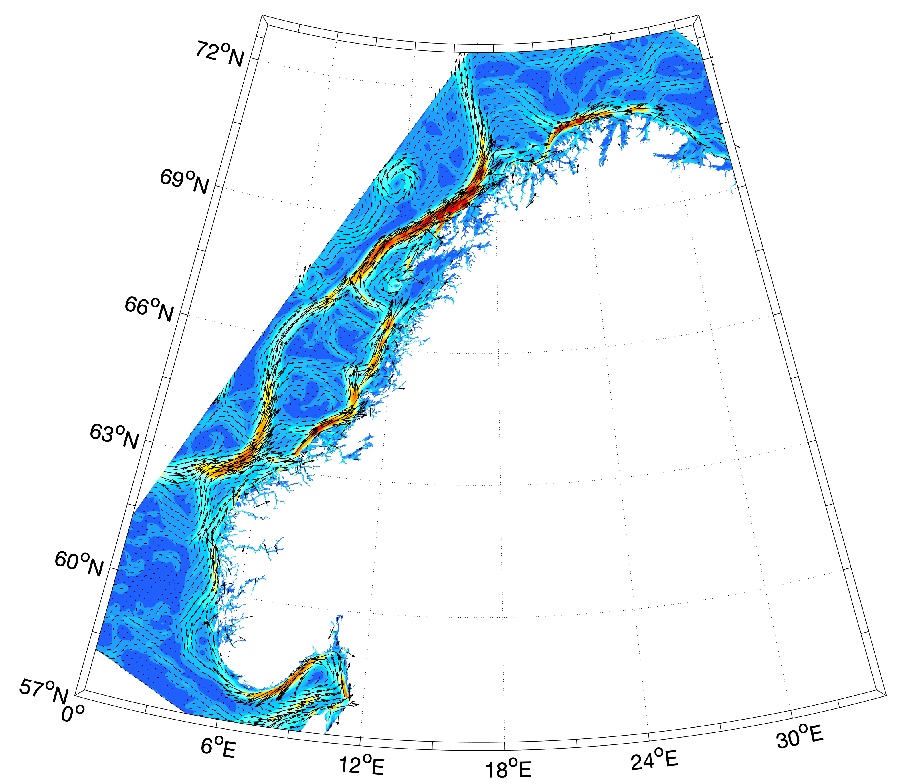
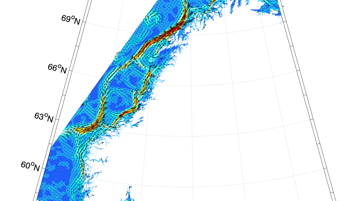
The figure shows the long-term average surface currents from an ocean model run performed by the Institute of Marine Research with the NorKyst800 model system. The model area covers the entire Norwegian coast with a grid that provides a horizontal resolution of 800m x 800m and 35 vertical levels. This model is forced by the high-resolution (3km) atmosphere model WRF (Weather Research and Forecasting Model) and by data from the weather forecast model at the Norwegian Meteorological Institute (AROME 2.5 km, Applications of Research to Operations at Mesoscale - Meteorological Cooperation on Operational Numerical Weather Prediction). for simulation periods close to present. Along the open boundaries, values from a 4km sea model have been used, also retrieved from the operational suite at the Norwegian Meteorological Institute. Freshwater runoff has been obtained from NVE (Noregs vassdrags- og energidirektorat), either from the hydrology model HBV or from observations. With its high horizontal resolution, the Norkyst800 model is able to provide a very realistic reproduction of currents and hydrography in coastal areas. The main features of the current field show a coastal current that follows the shelf slope, while current maps for shorter time periods (hours and days) will also show a significant meander and eddy formation.
Published: 19.03.2019 Updated: 12.04.2021
Sidebar
Contact